Win a Breathtaking Bryson City Giveaway
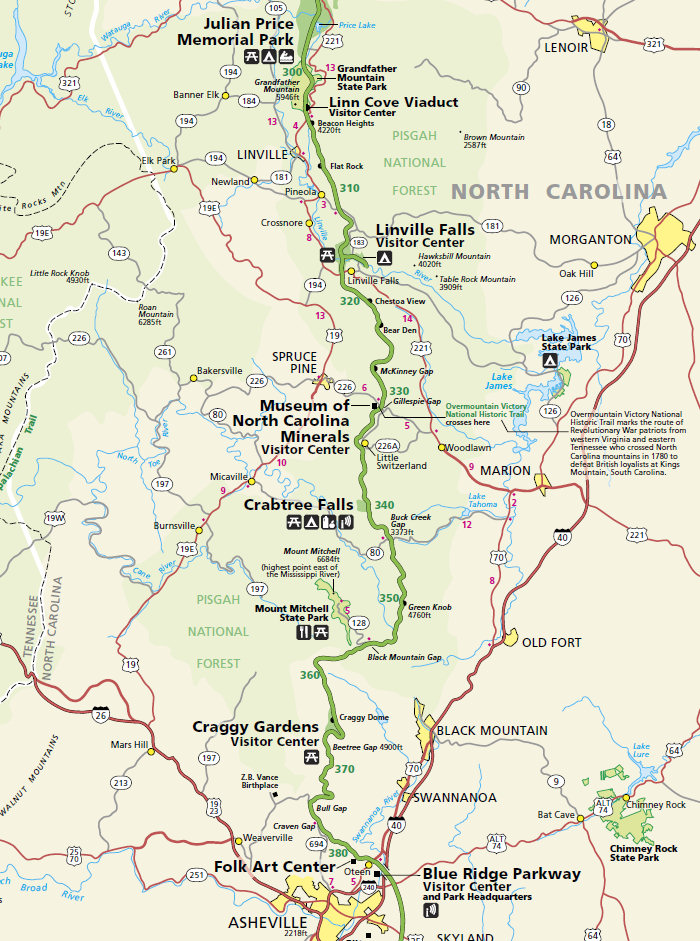
Here are parts of the official Blue Ridge Parkway map, with Milepost numbers every ten miles. The first map is the section north of Asheville to Grandfather Mountain. See our mile-by-mile list of Parkway things to do. Also, download a PDF of the entire official Blue Ridge Parkway Map (15 MB).
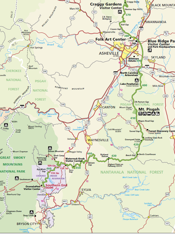
Here's a map of the Blue Ridge Parkway section south of Asheville to the Great Smoky Mountains:
Parkway Entrances & Exits in Asheville
You'll find entrances and exits to the Blue Ridge Parkway at most state and federal highway crossings. One exception is the intersection of Interstates 40 and 26. They do not provide direct access, but have signage to lead you. In Asheville, there are four primary entrances to the Parkway:
- Milepost 382.6: US Highway 70 crosses, the Folk Art Center is a short drive north. The best entrance for I-40 heading west.
- Milepost 384.7: US 74A, the best entrance from I-40 heading east.
- Milepost 388.8: US 25 crosses, from the Parkway, Biltmore is three miles north.
- Milepost 393.6: NC 191 crosses, the nearest entrance from I-26. The North Carolina Arboretum is located at this intersection.
Car GPS units do not work well on the Parkway since the Parkway does not use street addresses. But you can find everything easily by the mileposts and an old fashion map!
Blue Ridge Parkway FAQs
I'm not accustomed to driving in the mountains... how can I be safe?
Here are some things about driving the Parkway that will help ensure a safe visit. First of all, obey the speed limit and make use of the overlooks to enjoy the scenery and let other drivers get by. The Parkway is a bit steeper than most roads and the curves can sometimes "tighten" as you get into them. There are built-in distractions such as beautiful vistas, interesting cabins, bicyclists, and wildlife... watch out for them all! A good rule to keep in mind is "enjoy the view, but watch the road!"
Is there a toll or fee?
The Parkway is part of the National Park Service and FREE for all to enjoy. All of the hiking trails and attractions on the Parkway are also free. No commercial vehicles are allowed.
When is it open?
The Parkway is open 24 hours a day, every day. However, sections close in winter months due to snow and ice. Most of the Parkway is not plowed or treated with chemicals after a snow, so higher elevations are frequently closed in November through March. Road closures and conditions, along with weather reports, are available by calling the Parkway information line at (828) 298-0398. If the Parkway is closed for snow, it is still open for walking or cross country skiing!
Are there places to stop along the Parkway?
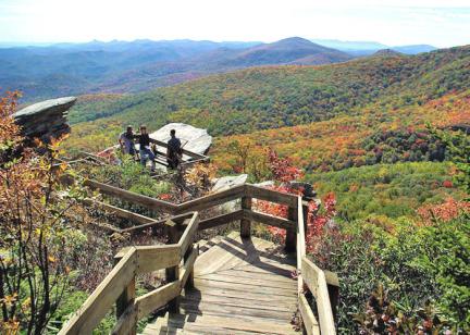
Yes, the frequent overlooks have space for parking while you enjoy the views or a nearby hiking trail. See a complete list of Parkway overlooks.
Can I picnic along the roadside?
In most places, picnicking is allowed on the roadside. This is a long-standing Parkway tradition, but you must be pulled completely off the road and please avoid soggy areas or ditches if we've had an abundance of rain. North of Asheville, NC, the Parkway goes through the city watershed and off-road parking is not permitted where indicated by signs. See our top Parkway Picnic Spots.
Will I have any problem getting my recreational vehicle through the Parkway tunnels?
The tunnels have clearance for RVs and campers. There are twenty six tunnels along the Parkway, one in Virginia and the others in North Carolina, mostly south of Asheville.
How do I get the best photographs along the Parkway?
No photographs adequately capture what you see with your eye from the Parkway's many overlooks, but here are a few tips that may help you out. Early morning or late afternoon sun is much better than mid-day when colors appear to be "washed out." Keep the sun at your back and have someone in your family or group in the picture as a way to personalize your visit.
Where do I buy gas?
No gasoline is available on the parkway. Gas is available not far off the Parkway at any of these US or State Highway Intersections in North Carolina near Asheville.
NC 181 — Exit at Parkway Milepost 312
US 221 — MP 317.5
NC 226 — MP 330.9
NC 226A — MP 334
US 70 — MP 382.4
US 74A — MP 384.7
US 25 — MP 388.1
NC 191 — MP 393.6
US 276 — MP 411.9
US 74/23 — MP 443.1
US 19 — MP 455.7